By Dr. Athanasios Staveris-Polykalas
The European Union’s Copernicus program, renowned for its advanced Earth observation capabilities, is set to expand its reach and enhance its impact with the introduction of six new missions, known as the Copernicus Expansion Missions. These missions are designed to fill gaps in current monitoring, address additional environmental and security needs, and provide more detailed data for managing Earth’s resources and responding to global challenges.
Existing Sentinel Satellites and Their Roles
The Sentinel satellites form the backbone of the Copernicus program, each designed for specific Earth observation purposes. Here’s an expanded look at the roles of each Sentinel satellite and how they contribute to our understanding and management of the Earth’s environment and resources:
Sentinel-1: Comprising two satellites, Sentinel-1A and Sentinel-1B, this mission uses C-band Synthetic Aperture Radar (SAR) imaging, providing all-weather, day-and-night imagery. This capability is critical for:
- Land Monitoring: Tracking changes in landscape, urban planning, and infrastructure monitoring.
- Agricultural Monitoring: Assisting in crop classification and monitoring agricultural practices.
- Forestry: Mapping forest cover and detecting deforestation.
- Disaster Management: Quick response mapping for floods, earthquakes, and oil spills, providing crucial data for disaster response and mitigation.
Sentinel-2: This mission includes Sentinel-2A and Sentinel-2B and focuses on high-resolution optical imaging across 13 spectral bands. Sentinel-2 excels in:
- Vegetation Monitoring: Tracking plant health, growth stages, and biomass estimation.
- Water Bodies Monitoring: Observing water quality, changes in rivers, lakes, and coastal areas.
- Land Cover Change: Detailed surveillance of habitat and landscape changes, aiding in land management and conservation efforts.
- Disaster Response: Providing imagery to assess damages and plan effective responses to natural disasters.
Sentinel-3: With its two satellites, Sentinel-3A and Sentinel-3B, this mission provides data primarily for ocean and land monitoring using a variety of instruments:
- Oceanography: Measuring sea surface temperature, sea surface height, and ocean color, which are vital for climate research and marine biology.
- Land Temperature: Monitoring thermal conditions of the land for environmental monitoring, urban heat islands, and fire detection.
- Vegetation State: Offering biogeophysical parameters of vegetation, supporting global agricultural and biodiversity monitoring.
Sentinel-4: This is a geostationary mission focused on monitoring the atmospheric composition over Europe, providing:
- Air Quality Monitoring: Tracking gases like NO2, SO2, O3, and aerosols, which affect human health and climate.
- Climate Action Support: Offering data to support policies on air quality and climate adaptations.
Sentinel-5 Precursor and Sentinel-5: These missions are dedicated to monitoring the atmosphere, measuring a multitude of trace gases that are related to air quality and climate. They provide:
- Atmospheric Gas Measurements: Daily global measurements of ozone, methane, formaldehyde, aerosol properties, carbon monoxide, and other air pollutants.
- Climate Monitoring: Supporting climate change models and mitigation strategies.
Sentinel-6: The latest addition, Sentinel-6 Michael Freilich (also known as Sentinel-6A), is primarily focused on measuring changes in global sea levels, an essential indicator of climate change. Its roles include:
- Oceanography: Providing accurate data on sea level rise to help predict weather events and long-term climate changes.
- Climate Research: Data from Sentinel-6 contributes to understanding the interconnected global climate system.
Together, these Sentinels provide a comprehensive view of the planet, covering land, ocean, and atmospheric monitoring. Their combined data streams are vital for ongoing efforts to manage natural resources sustainably, protect biodiversity, and respond effectively to natural disasters and climate change.
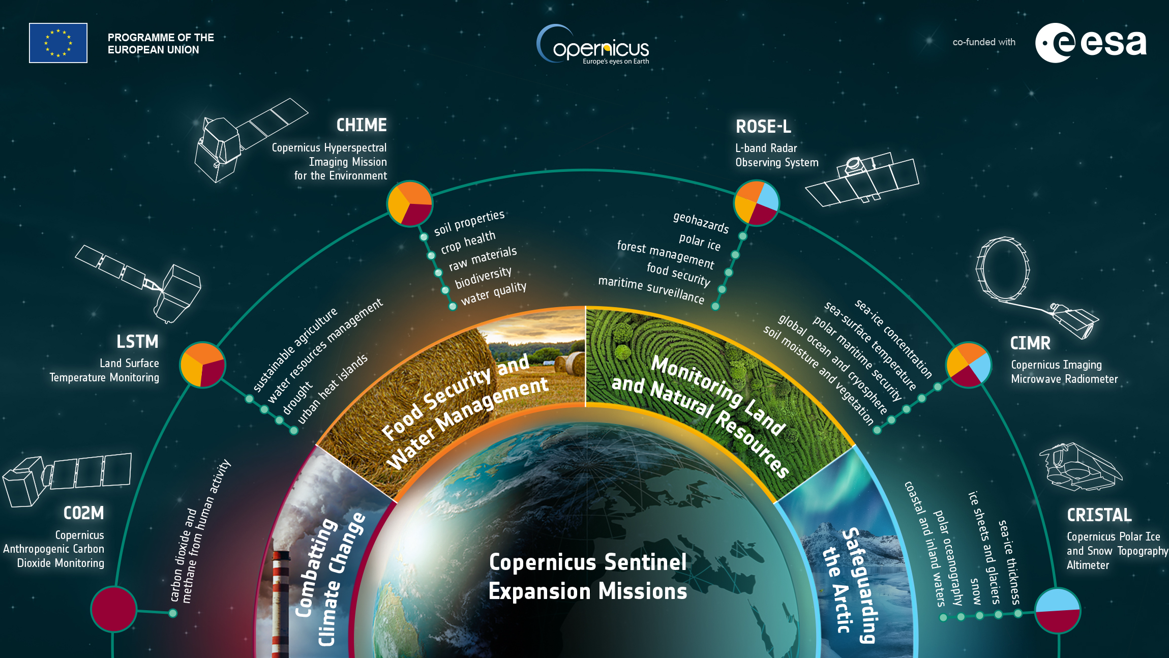
- CIMR (Copernicus Imaging Microwave Radiometer)
- Objective: To enhance the monitoring of the marine environment and sea ice.
- Technology: CIMR will utilize microwave radiometer technology to capture high-quality, all-weather, day-and-night images. It is specifically designed to provide wide-swath, high-resolution measurement of sea surface temperature, sea ice concentration, and salinity levels.
- Applications: This mission will support climate modeling and weather forecasting, enhance maritime navigation safety, and contribute to the monitoring of polar ice and global sea-level rise.
- CHIME (Copernicus Hyperspectral Imaging Mission for the Environment)
- Objective: To monitor terrestrial and coastal ecosystems by providing detailed hyperspectral imaging.
- Technology: CHIME will operate across a wide spectral range to capture data in visible, near-infrared, and short-wave infrared bands, allowing for detailed analysis of soil properties, vegetation health, and water quality.
- Applications: Useful in agriculture for optimizing crop management, in environmental protection for monitoring biodiversity and detecting pollution, and in forestry for assessing plant health and biomass.
- CO2M (Copernicus Carbon Dioxide Monitoring Mission)
- Objective: To measure carbon dioxide emissions from human activities with high precision.
- Technology: CO2M will use near-infrared and shortwave infrared spectrometers to accurately detect and quantify carbon dioxide concentrations, distinguishing between natural and anthropogenic sources.
- Applications: Essential for tracking and verifying greenhouse gas emissions, aiding policy compliance for international climate agreements, and facilitating targeted climate action strategies.
- LSTM (Land Surface Temperature Monitoring)
- Objective: To provide accurate and frequent monitoring of land surface temperatures worldwide.
- Technology: LSTM will utilize thermal infrared sensors to deliver detailed temperature data with high spatial and temporal resolution, capable of observing day and night conditions.
- Applications: Critical for urban planning (managing heat islands), agricultural monitoring (irrigation management), and environmental science (studying water cycles and ecosystem health).
- CRISTAL (Copernicus Polar Ice and Snow Topographic Altimeter)
- Objective: To monitor sea ice thickness and overlying snow depth, contributing to our understanding of climate interactions and sea-level rise.
- Technology: CRISTAL will be equipped with a dual-frequency radar altimeter and microwave radiometer to measure the height of ice and snow with unprecedented accuracy.
- Applications: Vital for climate research, improving sea-level rise predictions, and enhancing navigation in polar regions.
- ROSE-L (Radar Observing System for Europe-L Band)
- Objective: To provide detailed observation of vegetation and soil moisture content.
- Technology: Utilizing L-Band Synthetic Aperture Radar, ROSE-L can penetrate vegetation and surface layers to measure forest biomass and sub-surface moisture levels effectively.
- Applications: Supports forest management and agricultural practices by providing critical data on biomass growth and soil moisture, aiding in the management of water resources and food security.
These six new expansion missions will significantly augment the observational capacity of the Copernicus program, delivering crucial data needed to address environmental challenges, enhance climate change adaptation and mitigation efforts, and support sustainable development goals. By filling existing gaps in Earth observation data, these missions will not only extend the reach of Copernicus services but also improve the precision and effectiveness of its contributions to global monitoring and management tasks.
The Copernicus program is set to greatly enhance its Earth observation capabilities with the addition of six new Sentinel Expansion Missions. Each of these missions is designed to fill specific gaps in the current satellite coverage, addressing emerging environmental, agricultural, and climate monitoring needs. Here’s a detailed look at each new mission and the advanced technologies they will employ:
Strategic Importance for the European Union
1. Enhancing Environmental Monitoring and Protection
Copernicus plays a crucial role in the EU’s environmental policy framework, particularly in implementing the European Green Deal. By providing detailed and reliable data on climate, air quality, water quality, and land use changes, Copernicus enables the EU to monitor environmental targets, assess the effectiveness of environmental policies, and enforce regulations. This comprehensive monitoring capacity is essential for achieving the EU’s ambitious goals, such as biodiversity restoration, zero pollution, sustainable agriculture, and transitioning to a clean energy economy.
2. Contributing to Economic Resilience and Innovation
The data generated by Copernicus supports a wide range of industries critical to the European economy, including agriculture, forestry, energy, and maritime sectors. For instance, accurate Earth observation data can help optimize agricultural yields, manage forestry resources sustainably, plan energy infrastructure projects, and monitor maritime routes and activities. The downstream applications of Copernicus data not only drive economic growth but also spur innovation in sectors reliant on geospatial data, fostering a robust ecosystem of startups and technological advancements within the EU.
3. Supporting EU Security and Humanitarian Efforts
Copernicus contributes significantly to the EU’s security strategy by providing critical information for border surveillance, maritime security, and humanitarian response. The program’s capabilities in monitoring migrations, natural disasters, and other emergencies are invaluable for coordinating rapid responses and managing crises effectively. For example, the Sentinel satellites’ ability to monitor sea traffic and land movements aids in the fight against illegal activities, such as smuggling and trafficking, thereby enhancing the security of the EU’s external borders.
4. Advancing the EU’s Climate Leadership and International Commitments
Copernicus is fundamental to the EU’s leadership on global climate issues. The program’s extensive climate monitoring capabilities allow the EU to contribute significantly to international discussions on climate change, providing data essential for verifying compliance with global agreements like the Paris Accord. Additionally, by openly sharing its environmental data, the EU enhances global collaboration on climate research and policy-making, reinforcing its stance as a committed leader in global climate governance.
5. Shaping Sustainable Development and Global Policies
The EU leverages Copernicus data to influence and shape sustainable development both within and beyond its borders. This geo-information plays a crucial role in crafting policies that align with sustainable development goals (SDGs), addressing challenges such as urban sprawl, deforestation, water scarcity, and disaster risk reduction. The global nature of environmental challenges necessitates international cooperation, and through Copernicus, the EU positions itself as a key player in fostering global partnerships and strategies for sustainable development.
Conclusion
The strategic expansion of the Copernicus program, through the introduction of new missions, substantially enhances the EU’s capability to address these priorities. As the program continues to evolve, its integral role in shaping EU policies, advancing scientific understanding, and supporting socio-economic development becomes ever more pronounced, highlighting its value as a critical asset for the European Union and its global leadership.